iOS · Android · 50 US states

The only mile-marker app with live DOT integrations.

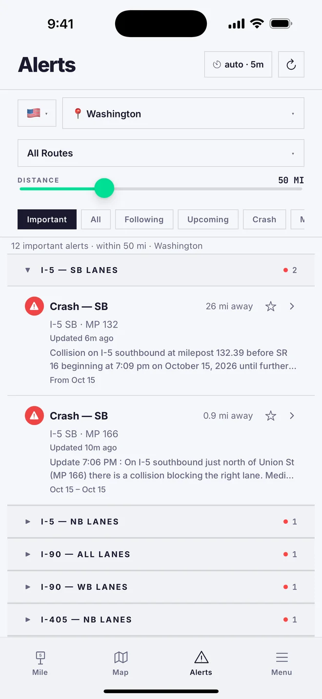
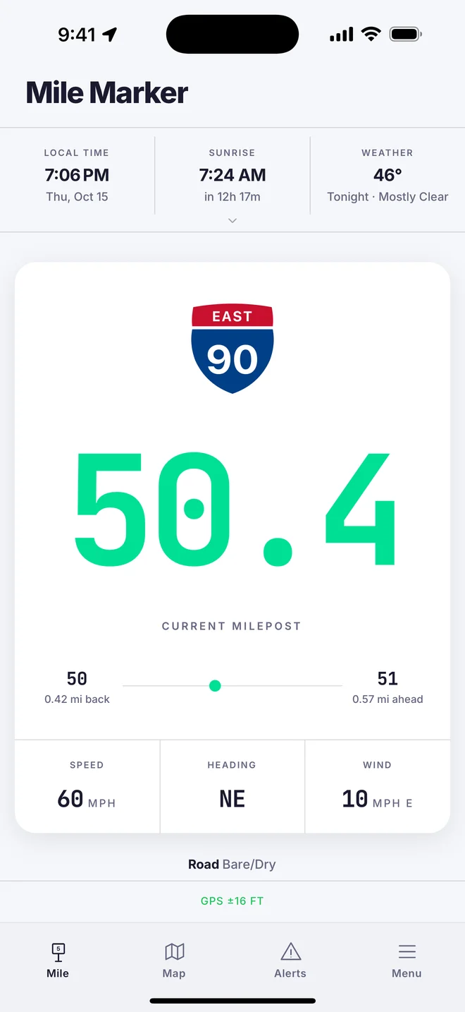
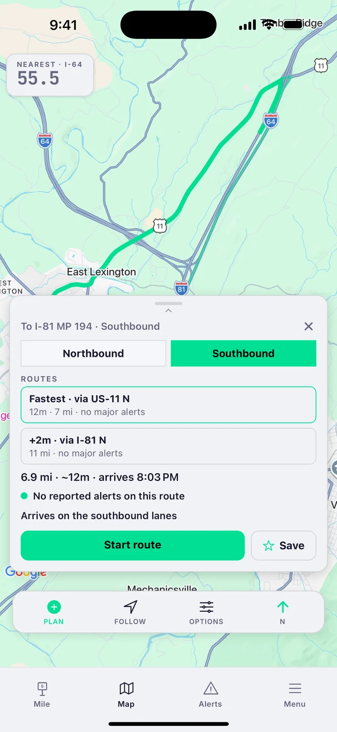
Real-time mile markers in all 50 US states. Live road alerts from 48 state DOTs — every state that publishes a usable feed (WY and RI don’t yet). Navigate to any mile marker on the map — because a milepost isn't just a number on a sign. It's how help finds you.

🚗 Now on CarPlay & Android Auto

Your mile marker is always free. Premium — map, live alerts, trip tools — $9.99/yr or $1.99/mo, 7-day free trial.

Real-time mile markers (50 states) · Live DOT alerts (48 states) · Border wait times · Seattle bridge status · Crosswind warnings · CarPlay & Android Auto · Works offline

Mile markers
50
US states
Always free
Live DOT alerts
48
of 50 US states
Every state with a usable DOT feed. Wyoming and Rhode Island don’t publish one yet.
Premium · $9.99/yr
Rating
5.0
“The app I didn’t know I needed and now cannot live without!”
★★★★★  dayjules, App Store

Far more than a mile marker.

STANDARD

What you’d expect.

Your nearest mile marker, live (all 50 states) · live DOT alerts · works offline · live map · GPS speed.

BONUS

The extras.

Border wait times · Seattle bridge status · crosswind warnings · trip logging · share your location · navigate to any milepost.

ONLY MILECHECK

What no one else has.

The only mile-marker app on both iOS & Android · the only one with live, nationwide DOT integrations (48 states) · the only CarPlay & Android Auto app that shows your mile marker · the only highway data layer tracking America’s drawbridges — live status and every federal opening rule.

See our live maps.

Free highway intelligence on the web, built on the same data as the app.

Why we built MileCheck.

My dad took a seasonal job driving snowplows for ODOT. Before long I realized how much of that job revolves around mile markers — every radio call, every crash report, every road closure. They’re how crews track where sand, salt, and brine have been applied, and how dispatchers coordinate a response.

If you call for help on a mountain highway, how do you tell anyone exactly where you are? That’s what mile markers are for. Most drivers pass hundreds of them without a second thought. But the people who keep roads open, respond to emergencies, and help stranded motorists rely on them every day.

There was one app for this, but it only worked on iPhone. My dad uses Android. So I built him a web app that showed his nearest Oregon mile marker from GPS. My mom, my sister, and I spent hours driving highways and back roads, checking numbers, making adjustments. I still remember the first time the number changed at exactly the right moment.

My dad showed it to coworkers. They showed it to others. Feedback came from truck drivers, road crews, first responders, and everyday drivers. Nearly every feature in MileCheck exists because someone on a real road asked for it.

What started as a simple tool for my dad turned out to be useful for a lot of other people, too.

MileCheck app icon
MileCheck iOS · Android · CarPlay · Android Auto

Find your milepost free — it’s how help finds you.

Get the app →

No account. We don’t track where you go.

No sign-up, no email, no phone number — just open it and drive. Your mile markers, trips, and location stay on your phone; we don’t collect or sell them, and there are no ads.

Read the full privacy policy →

Questions, answered.

What does MileCheck do?

It shows your nearest highway mile marker in real time, anywhere in all 50 states — plus live road conditions and alerts pulled straight from state DOTs. You always know exactly where you are, and what’s ahead on your route.

New to mile markers? Mile markers vs. GPS — why both still matter →

Which states are covered?

Mile markers in all 50 states. Live DOT alerts in 48 — every state that publishes a usable DOT feed. Wyoming and Rhode Island don’t yet; we’ll add them the day they do.

Does it work without cell service?

Yes — mile markers are stored on your phone, so they work in dead zones. Live alerts need a connection.

What’s free, and what’s premium?

Your current mile marker is always free. Premium — the live map, DOT alerts, and trip tools — is $9.99/yr or $1.99/mo, with a 7-day free trial.

Does it work with CarPlay and Android Auto?

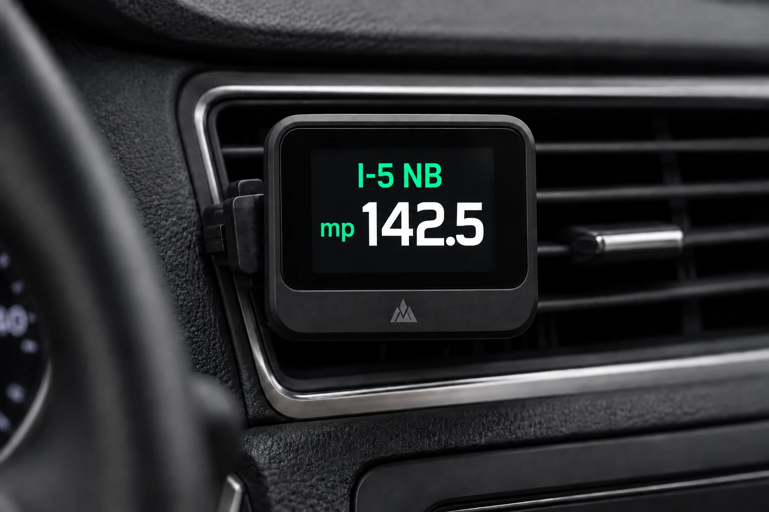
Yes, both — and the car screen is free. It’s deliberately simple right now: your highway, mile marker, and current road conditions, glance-and-go. It’s not the full app on the dashboard — just the one thing you need while driving, with no clutter. A richer car screen is on the way.

Can my company license the data?

Yes. The 50-state milepost corpus and the live 48-state DOT alert layer are available to license — one schema, one API, no state-by-state agency negotiations on your side. Fleets on Geotab can add MileCheck today from the Geotab Marketplace. For API access or fleet licensing, email info@milecheckapp.com — details on the B2B page.

Can I embed or republish MileCheck’s maps and data?

Newsrooms and public-interest sites are welcome to embed our live maps or cite the data with credit and a link — just tell us where it’s running. Any commercial use of the data or maps — inside a product, service, or paid publication — requires a license first: info@milecheckapp.com.

Beat the bridge. Beat the pass.

If you drive Seattle, MileCheck shows the city’s drawbridges — Fremont, Ballard, Montlake, University, South Park and more — raised or lowered, live on the map, so you can see if the bridge is up before you’re stuck behind it. Headed over the mountains? You get Snoqualmie and Stevens pass conditions and chain controls, straight from WSDOT.

For platforms and partners

The highway intelligence layer — licensable, integrable, already in production.

Most milepost data products stop at the static layer: “where is MP 142?” MileCheck delivers both — that milepost lookup plus live conditions at MP 142 right now, normalized from 48 state DOT feeds across 19 distinct upstream platform formats. One schema. One API response. No state contracts on your side.

Open a conversation →

Live on the Geotab Marketplace — the fleet add-in runs in MyGeotab today · data API by license.

50 states · 48 live DOT integrations
CarPlay & Android Auto

The mile marker is the location format institutions actually run on.

GPS didn’t retire the mile marker — it exposed how much emergency response, dispatch, and the entire highway data system still depend on it. The evidence is primary-sourced:

It’s what dispatch asks for

“When calling #77 or 911 for emergency assistance, providing the information on a mile marker sign will help responders reach you quickly.”
— Virginia DOT, official guidance

Cell-phone 911 location is often wrong

The FCC requires carriers to deliver an accurate location for only 80% of wireless 911 calls — and highways are the worst case, where cell towers line up in a row and triangulation fails.
— FCC E911 location-accuracy rules

The maps in your pocket won’t show it

Google and Apple Maps deliberately omit mileposts — Google’s own support threads tell users there’s no setting, and to use a dedicated app. The one number a responder needs is the one consumer maps won’t display.
— Google Maps support

The whole system is milepost-referenced

DOTs locate nearly everything — crashes, work zones, signs, 511 alerts — by route + milepost. Since 2014, FHWA’s ARNOLD mandate requires every state to maintain milepost-referenced inventories of all public roads.
— FHWA ARNOLD / Linear Referencing

Five layers, one stack.

01

Milepost corpus

Every interstate, US highway, and most state routes across all 50 states — sourced from official state DOT and government GIS records, never crowd-sourced. Quality-checked, normalized across state-by-state inconsistencies, and interpolated to one-tenth-of-a-mile precision between markers. Continuously updated as states add, reclassify, and re-route highways — a living dataset, not a one-time export. Bundled offline in the app; available as a structured dataset for integration.

02

DOT integration corpus

48 state DOTs integrated and growing, each a different upstream platform format. A serverless dispatcher normalizes every source into a single consistent road-conditions and incident schema, with caching tuned per source and resilient fallbacks for agencies with restrictive access.

03

Navigate-to-milepost primitive

The first consumer nav stack where a mile marker is a destination, not a display element. Tapping a milepost in the map hands off to Google Maps, Apple Maps, or Waze with the milepost coordinate as the routing target. Direct workflow value for dispatch-to-driver handoffs in fleet, roadside, and emergency-response use cases.

04

CarPlay & Android Auto

Live on CarPlay and Android Auto. Apple’s Driving Task entitlement requires a separate navigational utility review — it’s not a standard developer-portal option, and most transportation apps don’t qualify. MileCheck passed that review. The same data layer that powers the phone experience ships to the vehicle screen.

05

Real-time infrastructure status

Beyond DOT alerts: live commercial border-crossing wait times for all 82 US land crossings (commercial and FAST lanes, direct from CBP), plus live movable-bridge open/closed status — hyper-local, time-critical signals no consumer map surfaces. Live drawbridge status runs in Seattle and Florida (state DOT sensors) with Louisiana road/marine status behind it — and the federal opening rules for 800+ regulated US drawbridges are already normalized in the corpus, published as state-by-state web maps.

Seven segments where mile-marker precision is the missing layer.

01

Fleet management

“I’m at MP 184 on I-80.”

That’s how drivers report location. Telematics logs GPS coordinates — so dispatch can’t plot the one format drivers actually use without a manual lookup. We’re the translation layer.

02

Mapping & navigation

50 GIS negotiations · 19 schemas · or 1 license.

Adding a milepost layer yourself means fifty state negotiations and a pipeline to keep it current. Most platforms skip it. The corpus is licensable today.

03

511 / traveler information

One corridor. Five agency logins.

Cross-state alerts live in 50 incompatible DOT systems; aggregating them yourself means bilateral agreements with every agency on the route. We already normalized 48 of them.

04

Digital freight & logistics

“Meet the driver at I-80 MP 184.”

No native equivalent in consumer nav — drivers send approximate pins, dispatchers guess. Plus live commercial waits at all 82 land borders, an input no fleet platform surfaces today.

05

Roadside & incident response

“Can you find a sign and read it back?”

Stranded drivers report a mile marker; most dispatch systems demand a street address. The workaround is literally asking a stressed driver to go find a sign. We turn the marker into a routable point.

06

Towing & dispatch platforms

“Disabled vehicle, I-5 NB MP 164.”

Your board already receives that call. Plot it automatically — and flag whether that stretch is closed or under chain control right now. One API call, zero state-DOT contracts on your side.

07

State DOTs & agencies

The corridor doesn’t stop at the state line.

Watching conditions across a border means separate logins, schemas, and feeds per neighbor — the perennial unsolved consortium problem. One feed, every neighboring agency, one schema.

Run on road + mile? It plugs in.

If your operation speaks “route and milepost,” the layer drops into your stack — live conditions included, production-proven in a five-star app.

Open a conversation →

Building the data is harder than building the app.

MileCheck is the complementary layer, not a competitor to your routing or weather stack: direct-from-state-DOT road events — closures, construction, crashes, chain controls — tied to the exact mile marker. It runs alongside the nav and weather tools fleets already use. And it’s privacy-light by design — no driver accounts, and the vehicle’s location stays in your platform, not on our servers. A coordinate-to-milepost lookup is available elsewhere — the live conditions at that milepost, normalized across 48 agencies and proven in a five-star app, are the part that’s hard to copy.

50
state milepost corpus — sourced from official government GIS, quality-checked, never crowd-sourced
48
live agency integrations — production-proven, per-source cache tuning, resilient fallbacks
19
DOT platform formats — normalized into one consistent conditions and incident schema
24/7
monitored feeds — uptime tracked per state, alerting on stale or missing data at the source

Proven in production through the MileCheck iOS, Android, CarPlay, and Android Auto applications.

Validated continuously by a nationwide tester network — real drivers across the country who flag issues in the field, so a data problem surfaces before someone hits it in an emergency. Automated per-source monitoring catches the feeds; the testers catch the road.

↗ Live API status  ·  DOT feed uptime monitored 24/7

Why it’s hard to build in-house
  • Every agency is different — 48 integrations, each with its own auth method, rate limits, schema, and reliability characteristics. One upstream change breaks your feed until someone catches it.
  • No common standard — ibi511, COtrip, ArcGIS FeatureServer, GeoJSON / WZDx, CARS FEU-g, EVBG XML, and more. No two states publish the same data the same way.
  • State-by-state access — some feeds require registration, API keys, terms agreements, and back-and-forth with agency IT. Multiply that by 50.
  • Continuous normalization — route names, mile marker formats, and direction codes vary by state and change without notice. Keeping them aligned is an ongoing maintenance burden, not a one-time project.
  • Feed monitoring — DOT feeds go stale, change endpoints, and return unexpected errors. Without active per-source monitoring, your app silently serves outdated data.

MileCheck solved this once, in production, for a consumer app with five-star ratings on both stores. The platform is available to license today — no agency negotiations required on your side.

Pick the model that fits — we're flexible.

API access

The unified DOT alerts feed — direct from 48 state agencies: closures, construction, crashes, and chain controls — plus live commercial border-crossing waits from all 82 US land crossings (CBP), served through one normalized endpoint.

Data licensing

The 50-state milepost corpus as a static dataset or continuous sync, shaped to your schema.

White-label SDK

Mile-marker display and DOT alert integration embedded directly into your existing driver app.

Joint development

Co-engineering a vertical use case on top of the highway intelligence layer.

Live road conditions on a screen in your venue.

A MileCheck corridor board turns any TV in a truck stop, travel center, diner, or gas station into a live dashboard for the highway outside your door — closures, crashes, chain controls, and weather for your stretch of interstate, updating around the clock from the same direct-from-DOT layer that powers the app.

For venues

The board is free. We configure it for your corridor and your location — drivers walk in, see exactly what's ahead on their route, and your venue becomes the place that knows the road.

For sponsors

One sponsor slot per screen — your brand alongside the one piece of information every driver in the building actually came in wondering about.

How it runs

Any screen with a browser — no hardware to buy, nothing to install or maintain. The board is a live web page that keeps itself current.

To put a board in your venue — or your brand on one — email info@milecheckapp.com.

Get in touch.

For partnership and platform inquiries, contact info@milecheckapp.com.

Now on the Geotab Marketplace

Already run a fleet platform? MileCheck drops in as an Add-In.

It installs inside MyGeotab and Geotab Drive as an Add-In — the driver’s live mile marker and direct-from-DOT alerts, right in the dashboard. Same normalized data layer, no rebuild on your side.

The Monthly Road Report

Get the report in your inbox

Real numbers on what actually happened on America's highways last month. Once a month. No spam.