iOS · Android · 50 US states

The only mile-marker app
with live state DOT data.

Real-time mile markers in all 50 US states. Live road alerts from 42 state DOTs. Navigate to any mile marker on the map — because a milepost isn't just a number on a sign. It's how help finds you.

Your mile marker is always free. Premium — map, live alerts, trip tools — $9.99/yr or $1.99/mo, 7-day free trial.

Mile markers
50
US states
Live DOT alerts
42
of 50 US states
New states added weekly toward all 50. Tracking state-by-state — see coverage list ↓
Rating
5.0
and a 0.00% crash rate

Two things no one else has.

01

The only mile-marker app on Android.

Truckers, road crews, and EMTs were left out of the iOS-only mile marker app ecosystem for years. We built MileCheck on both platforms from day one — the same code, the same offline data, the same mile markers in all 50 states.

02

The only app on either store with live, nationwide DOT API integrations.

Closures, crashes, construction, weather warnings — pulled directly from 42 official state DOT feeds, not scraped from third-party sources. When your state DOT publishes an alert, MileCheck users see it. The integration corpus expands state by state, with new states added weekly toward all 50.

Why we built MileCheck.
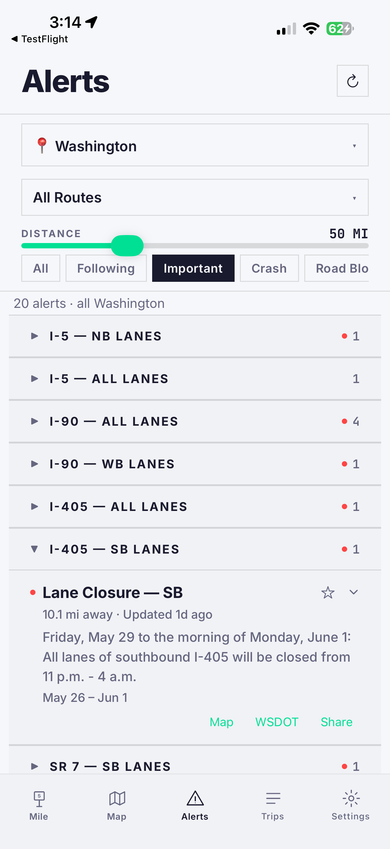
Last winter, my dad took a seasonal job driving snowplows for the Oregon Department of Transportation. Like many DOTs across the country, ODOT needed more drivers, and before long he was out on the highways in the middle of winter storms, helping keep the roads open.

What I didn’t realize at the time was how much of that job revolves around mile markers. Every radio call references them. Every crash report. Every road closure. They’re how crews report conditions, track where sand, salt, and brine have been applied, and coordinate a response.

Once I started paying attention, I noticed mile marker references everywhere. Crash alerts. Road closures. Emergency responses. Tow trucks. Maintenance crews. Dispatchers.

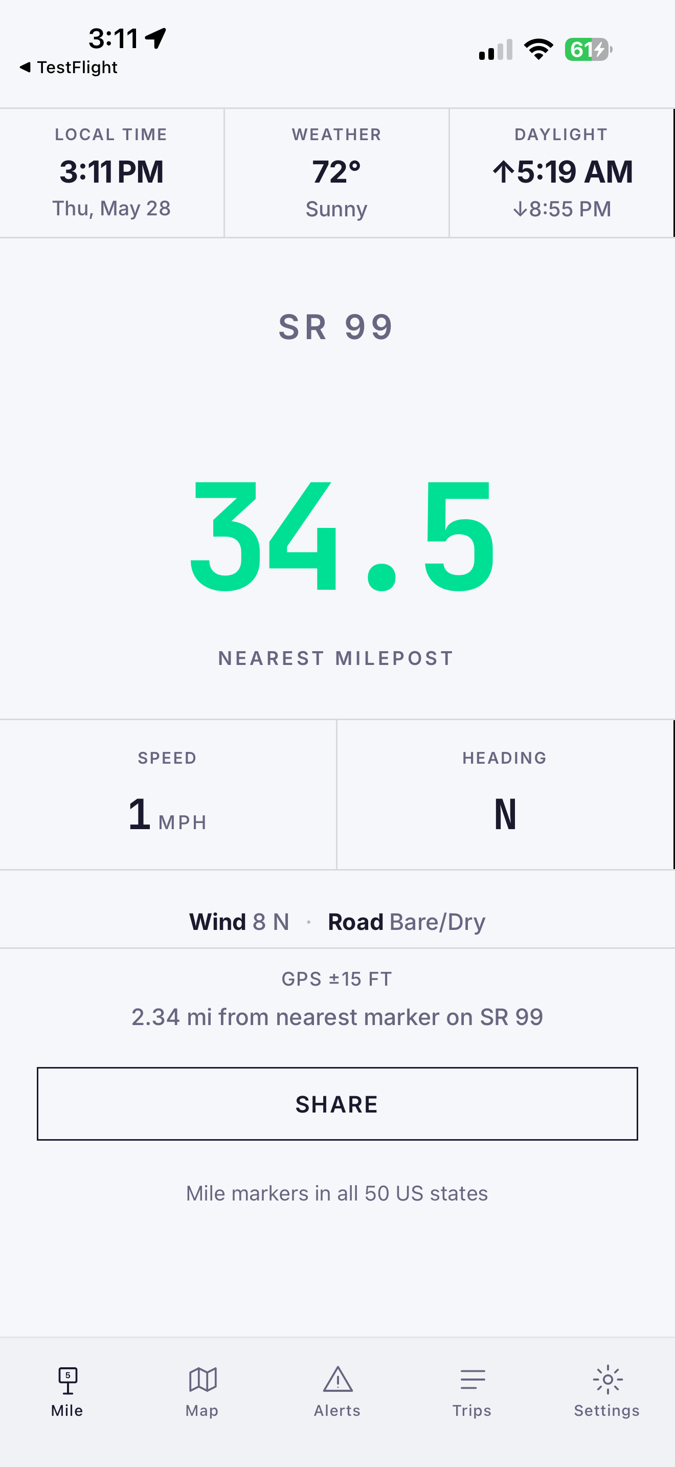
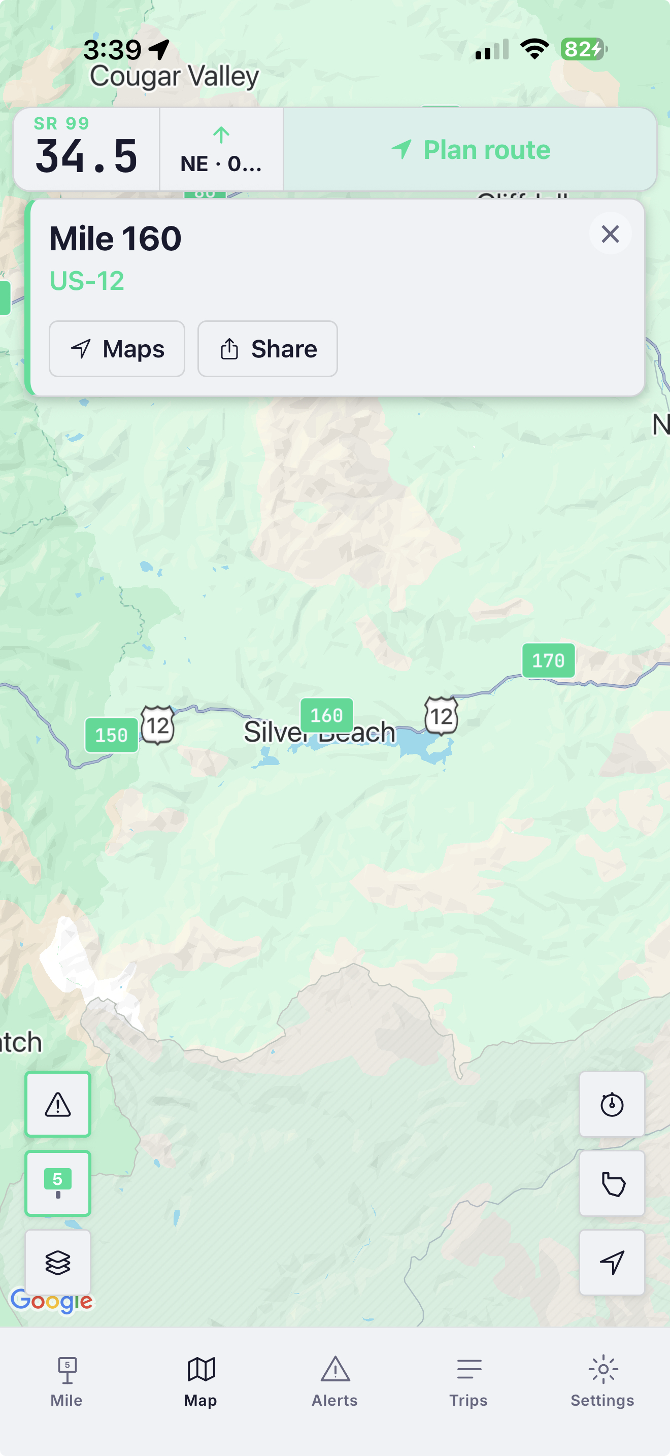
If you call for help on a mountain highway, how do you tell anyone exactly where you are?

That’s what mile markers are for.

Most drivers pass hundreds of them without a second thought. But the people who keep roads open, respond to emergencies, and help stranded motorists rely on them every day.

The problem is that knowing your exact mile marker isn’t always intuitive, and they aren’t built into most major navigation apps. Signs get missed, damaged, or stolen. Snow covers them. Staring at the shoulder waiting for a small green sign while you plow through a storm isn’t exactly ideal.

There’s an app people use for this, but it only works on iPhone. My dad uses Android, and so do many of the drivers around him. Asking him to switch phones for a single app was never realistic, so I built him a simple web app that showed his nearest Oregon mile marker from his GPS location.

As it grew, it became a family effort. My mom, my sister, and I spent countless hours driving highways and back roads, checking mile markers, comparing numbers, making adjustments, and trying again.

I still remember the first time the number changed at exactly the right moment. We were SO excited — it felt like magic every time we passed a milepost.

My dad showed it to a few people at work. They showed it to others. Soon feedback was coming in from truck drivers, road crews, first responders, and everyday drivers. Nearly every feature in MileCheck exists because someone using it on a real road asked for it.

Today, MileCheck does a lot more than show mile markers. It helps drivers find their location, stay ahead of road conditions, and plan long drives.

What started as a simple tool for my dad turned out to be useful for a lot of other people, too.

Find your milepost free — it’s how help finds you.

Get the app →

The whole app, end to end.

Made for everyone who’s ever needed to say “I’m at milepost 142.”

01

Truckers

Dispatch needs an exact location. The mile marker just blew past you at 65 mph.

MileCheck reads your nearest mile marker in real time. One number to report.

02

DOT workers, EMTs & first responders

You’re responding to a crash and need to confirm the milepost fast — or you’re laying salt, sand, or brine and logging every pass on paper, then burning another hour after a 12-hour shift typing it into the system.

Live mile markers, a DOT incident overlay, and one-tap trip logging that exports at the end of your shift — no re-entering a paper log after 12 hours on the road.

03

Road trippers

You’ve got a flat on a dark highway, service is spotty, and you’re halfway between mile markers. “I’m somewhere on the highway” won’t help anyone find you.

Pull up MileCheck: “I-90 westbound, between mile 142 and 143.” Read it to whoever’s coming, or tap share to send it — a real location, not a vague pin in a green field.

04

Commuters

Closures, crashes, construction. You’d rather hear about them before you hit them.

Check your highway route in advance — delays, closures, crashes, construction, each showing when the DOT last updated it, urgent and long-term alike. Follow the ones you care about. In Seattle, see if a drawbridge is up before you head home or into the city.

05

Dispatchers and operations teams

Your driver is stuck at “somewhere between Pendleton and Boise.” You need to send help to a specific point on a specific highway.

MileCheck gives every milepost a coordinate, a state, a route, and a navigate-to button. Dispatch reads one number. Field crew taps Maps and goes.

← swipe for more →

Seven things, done well.

01

Navigate to any mile marker with one tap New

Hands off to Google Maps, Apple Maps, or Waze with the milepost as your destination. The first nav app where a mile marker is a destination, not just a sign.

02

Mile markers, all 50 states

Every interstate, US highway, and most state routes. Bundled offline so you keep working in no-service areas.

03

Live DOT alerts in 42 states

Closures, crashes, construction, weather, chains. Direct from 42 state DOTs — see the list ↓. New states added weekly toward all 50.

04

Pre-trip route planning Premium+

Plan a corridor, see only the alerts affecting your drive. Hand off to your nav app when you're ready.

05

Trip logging

Opt in when you want it. Records your route with multi-segment tracking, stays on your device, never transmitted.

06

Multi-state coverage that actually works

Cross from Idaho into Montana. The state, the route format, and the live data source all switch automatically.

07

Offline-ready by default

Mile marker data ships with the app. No download, no setup, no “oops you’re in a canyon” moments.

50 states of mile markers. Live DOT alerts in 42.

Every state has mile markers. The deeper green shows where live DOT alerts are running today — 42 and counting, with new states added every week.

Mile markers — all 50 states Live DOT alerts — 42 states

Start free. Upgrade when you need more.

Finding your mile marker is always free — no account, no trial, no paywall, even in an emergency. And no ads, ever. The subscription adds the map, live DOT alerts, and trip tools.

Free
$0
free forever · no account
  • Real-time mile marker — always free
  • GPS speed & heading
  • All 50 states bundled offline
  • Light & dark mode
  • No ads, ever

Always free, even in an emergency — your location is never behind a paywall, and no ads, ever.

Premium+
Included with Premium
Free for Premium subscribers through June 30, 2026. Pricing announced before it changes.
  • Everything in Premium
  • Pre-trip route planning
  • Alerts on your planned corridor
  • Navigate to any mile marker
  • Hand off to Google Maps, Apple Maps, or Waze
Get the app →

Building something on top of mile marker data?

MileCheck operates a multi-state mile marker + DOT alert ingestion platform that today serves consumer drivers on iOS and Android. The same data layer — 50 states of bundled mileposts, 42 state DOT integrations and growing, normalized route mappings, navigate-to-milepost handoff — has direct relevance to fleet management platforms, mapping and navigation tools, 511 traveler-information operators, digital freight brokerages, and roadside assistance providers.

If you're working on something where precise highway location matters — whether that's API access, data licensing, integration partnerships, or something we haven't thought of — we'd like to hear from you.

info@milecheckapp.com Learn more → Direct line for partnership and platform inquiries.

For platforms and partners

The highway data layer your platform doesn't have to build.

50 US states of bundled mile markers. 42 state DOT integrations, expanding weekly toward all 50. Normalized route mappings across 19 distinct DOT platform formats. A consumer-grade mobile interface already shipped to iOS and Android.

Open a conversation →

Three layers, one stack.

01

Milepost corpus

Every interstate, US highway, and most state routes across all 50 states — sourced directly from official state DOT and government GIS milepost records, never crowd-sourced or estimated. Real signed-marker coordinates, route IDs, direction, and mile numbers, quality-checked per state for outliers and bad coordinates, normalized across state-by-state inconsistencies, and interpolated to one-tenth-of-a-mile precision between markers. Bundled offline in the consumer app for no-service operation; available as a structured dataset for platform integration.

02

DOT integration corpus

42 state DOTs integrated and growing. Each integration handles a different upstream platform format — 19 distinct platform shapes in all. A serverless dispatcher normalizes every source into a single consistent road-conditions and incident schema, with caching tuned per source and resilient fallbacks for agencies with restrictive access.

03

Navigate-to-milepost primitive

The first consumer nav stack where a mile marker is a destination, not a display element. Tapping a milepost in the map hands off to Google Maps, Apple Maps, or Waze with the milepost coordinate as the routing target. Direct workflow value for dispatch-to-driver handoffs in fleet, roadside, and emergency-response use cases.

Highway location precision is the data layer your driver-facing apps need.

Most consumer navigation apps (Google Maps, Apple Maps, Waze) don't include mile markers as a routing primitive. The data exists at the state DOT level, but it's locked behind 50 different platforms, 19 distinct API formats, and a long tail of state-by-state inconsistencies in route naming, milepost intervals, and direction encoding. Building it in-house means starting from scratch on all 50 — discovering each platform, working through access one agency at a time (many DOT feeds aren’t public; each has its own registration, and some require emailing or calling the agency directly for credentials), and re-solving every route-normalization edge case along the way.

MileCheck has done the integration work. The result is a unified, normalized, real-time highway location layer with a consumer-grade mobile interface as proof of operation. The same layer can power:

  • Fleet management driver apps that need mile-marker reporting and DOT alert overlays on the driver's primary screen
  • Mapping platforms that want to add milepost-aware POIs and routing primitives to their existing tile data
  • 511 traveler-information operators that want to consolidate cross-state DOT data without negotiating 50 individual feeds
  • Digital freight brokerages that need precise origin, destination, and waypoint targeting at the milepost level
  • Roadside assistance dispatchers that need exact field-crew routing to a driver-reported milepost

And it’s been field-tested by the people it’s built for. Real DOT workers ran MileCheck in their daily work and sent feedback every day through development — domain validation from actual end users that an internal team can’t easily reproduce. The product is already shaped by the operators who live on the road.

Conversations open across six segments.

Segment 01

Fleet management

Telematics platforms and driver apps where mile-marker reporting closes the dispatch-handoff gap. MileCheck data layer integrates as an SDK, an API, or a parallel app surface — whatever fits your driver-UX architecture.

Segment 02

Mapping and navigation

Add a milepost layer to your tile data without negotiating 50 state DOT contracts. We've done the normalization work and can deliver as a continuous data feed or a per-state corpus.

Segment 03

511 / traveler information

Cross-state aggregation of DOT alerts under one normalized schema. Useful for interstate corridor consortia, regional 511 operators, and state agencies seeking neighbor-state integration without bilateral negotiations.

Segment 04

Digital freight and logistics

Load matching, track-and-trace, predictive ETA — all benefit from milepost-precision origin and destination targeting. The "drop trailer at MP 87 of I-80" workflow is currently impossible in consumer nav. MileCheck makes it routable.

Segment 05

Roadside assistance and incident response

Service vehicle ETA depends on dispatch precision. MileCheck's navigate-to-milepost capability eliminates the "find a closest address" workaround that today bottlenecks roadside fulfillment.

Segment 06

Direct-to-consumer growth

The consumer app is its own revenue stream, independent of any integration. The market reaches well beyond professional drivers — anyone who lives near a drawbridge, skis a mountain pass, or road-trips an unfamiliar highway. User base and price both scale with marketing investment that hasn’t been spent yet.

Pick the model that fits — we're flexible.

  • API access to the unified DOT alerts feed (today's Worker is one endpoint away from public deployment)
  • Data licensing for the 50-state milepost corpus
  • White-label SDK integration into your existing driver app
  • Joint product development — co-engineering a vertical use case on top of the layer
  • Something else — we're open to ideas that don't fit the above

Each conversation starts at info gathering. We don't have a salesperson. You'll be talking to the founder.

Shipped, live, measurable.

50
states — bundled mile markers, every interstate and US highway, most state routes
35
states — live DOT alerts in production today, expanding weekly toward all 50
2
platforms — iOS App Store and Google Play, identical feature sets, identical underlying data layer

And it runs lean. The whole platform — a Cloudflare Worker, R2 storage, Expo, and a lightweight routing API — runs on a small fixed monthly cost, with no metered dependency on expensive turn-by-turn nav-API pings. Margins scale with users, not with infrastructure spend.

The integration engine isn't capped at state DOTs.

Alert classification and filtering already improve continuously — sorting closures, crashes, construction, and weather by severity, route, and direction, and getting sharper with every state added. The same engine that normalized 42 state DOTs extends to entirely new authorities and transportation modes. We've already proven it once at the city level.

Already proven

City DOT

Real-time Seattle drawbridge status — Ballard, Fremont, University, Montlake and more — is already live via SDOT. The same pattern extends to any city's bridges, signals, and closures.

Opportunity

County DOT

County road authorities publish closures and conditions no consumer app surfaces today. Same integration model, an untapped layer of coverage.

Opportunity

Rail

Highway-rail grade crossings, crossing delays, and freight-rail conflicts — safety-critical data absent from every consumer navigation app.

Opportunity

Marine & water

Ferry schedules and status, drawbridge openings, and waterway crossings — the first- and last-mile gaps for coastal and island corridors.

We're a small team.

For partnership and platform inquiries, contact info@milecheckapp.com.